Yuleba to Wallumbilla ‘Country Cattle Loop’
TOURIST DRIVE 2
Leave the highways behind and take the roads less travelled for a lesson about life on the land. Enjoy a series of historical sites along the way, offering an insight into early settlement of the area.
START: YULEBA
END: WALLUMBILLA
TOTAL DRIVING DISTANCE: 102.1KM
ALLOW: A FEW HOURS / HALF DAY
Directions
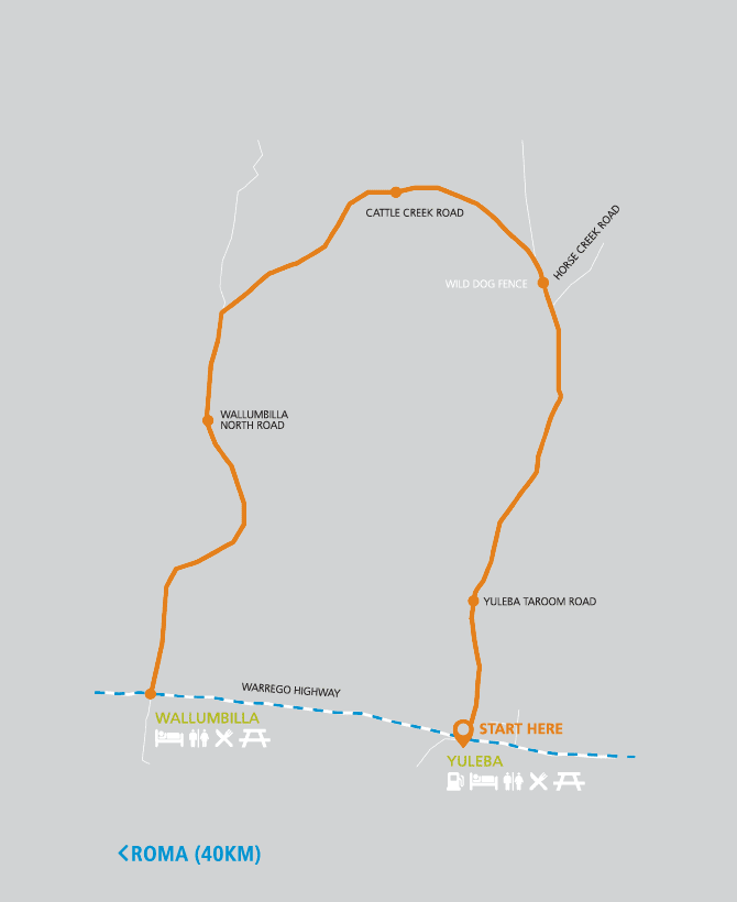

- From the Water Tower in Yuleba, head east on the Warrego Highway for 1km.
- Turn left onto the Yuleba-Taroom Road and continue for 12km. Pull over on the left to see the Bendemere Station Heritage Site.
- From the Bendemere Station Heritage Site, continue for 26.7km (Don’t turn right onto Horse Creek Road). Keep your eyes peeled for the Wild Dog (Dingo) Barrier Fence on both sides of the road – the longest fence in the world.
- Continue on the Yuleba-Taroom Road for 14.1km then turn left onto Cattle Creek Road.
- Continue on this road for 20.6km to the intersection.
- Turn left onto Wallumbilla North Road and continue for 13km. Be sure to stop in to see the Chadford State School Heritage Site on the right.
- From the Chadford State School Heritage Site, continue on Wallumbilla North Road for 7.1km, turn left at the intersection to remain on the same road for 7.6km. You are now at your final destination – Chadford Street, Wallumbilla.
- Return to Roma, driving 40km or approximately 30 minutes.
All roads on this journey are sealed,
making this suitable to drive in all
weather, though please be aware of
industry vehicles that could be using this
road and always drive to conditions.